By Steve Pak, | February 23, 2016
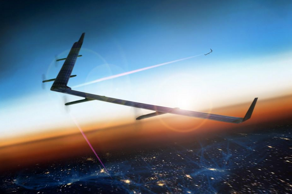
Facebook Internet Drone
Facebook's engineers are using artificial intelligence (AI) to analyze images of Earth and figure out where people are living. The social network can then use lasers, drones, and satellites to beam Internet access to those people most efficiently.
During Spring 2014 Facebook rolled out its Connectivity Lab. The goal was to build new technologies such as flying Internet-beaming drones that would use more efficient methods to deliver Internet access to the rest of the world.
Like Us on Facebook
However, one key issue is for the internet drones to beam signals to areas that include living people. It can be quite challenging due to the world's large size.
Yael Maguire heads the Facebook Connectivity Lab. He explains that the social network could not answer the basic question of where people live, which makes up only one percent of the Earth.
Facebook decided to use AI to create a worldwide map. It shows how the new Internet tech can most efficiently bean the web to the world's population.
A Facebook engineer and optical physicist built a system that analyzes satellite images of Earth's surface, and then determines precisely where people are living, according to Wired. The new system is also helping to develop the flying drones.
Deep learning by AI involves "neural networks." Such hardware and software networks can map the web of neurons in a human brain.
For example, adding enough spoken words into a neural net allows it to recognize commands spoken into smartphones. It can also analyze sattelite photos and use machine learning to figure out where people are living.
The system requires labeled data to work. Humans must identify some excellent examples before they are added to the neural net.
Facebook's trainers did not label specific evidence of human civilization such as houses, roads, or farmland. They just asked the AI if there were any signs of humans in the image.
The neural net included 8,000 overhead pictures of India. Afterwards the neural net could recognize evidence of human life in photos of around 20 other countries.
Facebook's system analyzed 360 terabytes of images that represented 21.6 million square kilometers of planet Earth, according to PC Mag. Maguire reports the error rate was less than 10 percent.
Here's Facebook's solar-powered Internet drone:


-
Use of Coronavirus Pandemic Drones Raises Privacy Concerns: Drones Spread Fear, Local Officials Say

-
Coronavirus Hampers The Delivery Of Lockheed Martin F-35 Stealth Fighters For 2020

-
Instagram Speeds Up Plans to Add Account Memorialization Feature Due to COVID-19 Deaths

-
NASA: Perseverance Plans to Bring 'Mars Rock' to Earth in 2031

-
600 Dead And 3,000 In The Hospital as Iranians Believed Drinking High-Concentrations of Alcohol Can Cure The Coronavirus

-
600 Dead And 3,000 In The Hospital as Iranians Believed Drinking High-Concentrations of Alcohol Can Cure The Coronavirus
-
COVID-19: Doctors, Nurses Use Virtual Reality to Learn New Skills in Treating Coronavirus Patients
